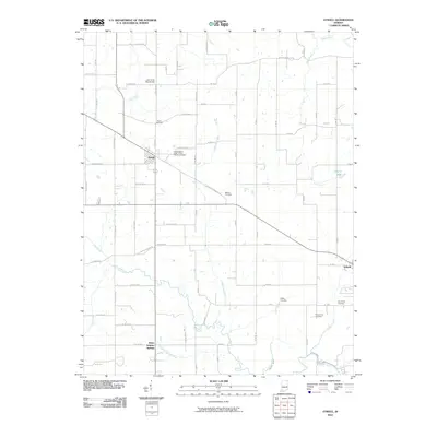
2010 Map of Otwell
USGS Topo · Published 2010About this map
Otwell serves as the primary hub in this southern Indiana landscape, where agriculture and hydrology define the local character. Located near the southern boundary, the Patoka River and County Ditch wind through the terrain, joined by several local waterways including Little Flat Creek and Altar Creek. This 2010 survey highlights a high density of rural burial grounds, which offer significant value for genealogical research in Pike County. Noteworthy sites include the Independent Order of Odd Fellows Cemetery adjacent to the town center, and the Mount Zion Cemetery further east. The eastern edge features the settlement of Ireland, while the southwest corner identifies White Sulphur Springs along Sulphur Springs Brook. The area's water management is evident through landmarks like the Lake in the Woods Dam and Ireland Lake, illustrating how the community has shaped the natural drainage of the Patoka watershed.
Find a feature on this map
52 named features on this map. Tap any name to fly to it.
Don’t see what you’re looking for? This feature index may not catch every label — zoom into the map to look around manually.
Map Details
Editions of this 2010 Otwell Map
This is the sole edition of this map. No revisions or reprints were ever made.
Other maps of this area

1902 · Ditney
USGS Topo · 1:125,000

1903 · Velpen
USGS Topo · 1:62,500

1944 · Glendale
USGS Topo · 1:24,000

1945 · Sandy Hook
USGS Topo · 1:24,000

1946 · Jasper
USGS Topo · 1:24,000

1954 · Huntingburg
USGS Topo · 1:24,000

1956 · Alfordsville
USGS Topo · 1:24,000

1956 · Vincennes
USGS Topo · 1:250,000

1957 · Vincennes
USGS Topo · 1:250,000

1958 · Vincennes
USGS Topo · 1:250,000