
1943 Map of Outland
USGS Topo · Published 1962About this map
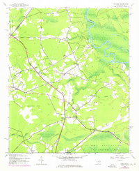
Britton Neck and the winding Pee Dee River define this coastal plain landscape during the early 1940s. The region is characterized by a dense network of crossroads and small settlements, including Outland, Williams Hill, and Pleasant Hill, which served as local hubs before modern highway expansion. The map details a landscape transition from the swampy bottomlands of Boser Swamp and Bells Swamp to the higher ground of Sand Ridge.
Find a feature on this map
42 named features on this map. Tap any name to fly to it.
Don’t see what you’re looking for? This feature index may not catch every label — zoom into the map to look around manually.
Map Details
Editions of this 1943 Outland Map
2 editions found
Other maps of this area

1943 · Yauhannah
USGS Topo · 1:24,000

1943 · Henry
USGS Topo · 1:24,000

1943 · Carvers Bay
USGS Topo · 1:24,000

1943 · Plantersville
USGS Topo · 1:24,000

1943 · Dongola
USGS Topo · 1:24,000

1943 · Rhems
USGS Topo · 1:24,000

1944 · Outland
USGS Topo · 1:31,680

1946 · Johnsonville
USGS Topo · 1:62,500

1949 · Georgetown
USGS Topo · 1:250,000

1967 · Georgetown
USGS Topo · 1:250,000