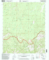
1998 Map of Outlaw Draw
USGS Topo · Published 2000About this map
The Mogollon Rim forms a dramatic geological divide across this portion of Navajo County, separating the Sitgreaves National Forest from the Fort Apache Indian Reservation to the south. This late-twentieth-century survey highlights a landscape defined by ranching history and forest management, where the Blevins Ranch and the former Bunger Ranch (Site) represent early settler footholds in a water-scarce environment. The map details an extensive network of drainage basins, including Baldwin Draw and Phoenix Park Wash, along with numerous stock tanks such as Salt Tank and West Buckskin Tank that supported the local cattle industry.
Find a feature on this map
51 named features on this map. Tap any name to fly to it.
Don’t see what you’re looking for? This feature index may not catch every label — zoom into the map to look around manually.
Map Details
Editions of this 1998 Outlaw Draw Map
This is the sole edition of this map. No revisions or reprints were ever made.
Other maps of this area

1886 · Holbrook
USGS Topo · 1:250,000

1893 · Holbrook
USGS Topo · 1:250,000

1954 · Holbrook
USGS Topo · 1:250,000

1957 · Holbrook
USGS Topo · 1:250,000

1958 · Holbrook
USGS Topo · 1:250,000

1960 · Holbrook
USGS Topo · 1:250,000

1961 · Clay Springs
USGS Topo · 1:62,500

1961 · Heber
USGS Topo · 1:62,500

1961 · Cibecue
USGS Topo · 1:62,500

1961 · Chediski Peak
USGS Topo · 1:62,500