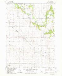
1979 Map of Owasa
USGS Topo · Published 1980About this map
The Iowa River winds through the northern portion of this landscape, its banks punctuated by small riverside developments and access points like the Eagle City Access Area and Cross Ford Access Area. In the center of the sheet, the settlement of Owasa sits at a transportation nexus, where local roads meet the diagonal tracks of the Chicago and North Western railroad. The map reveals a deeply rooted rural infrastructure of the late 1970s, evidenced by the distribution of numerous community burying grounds including Kidwiler Cem, Oakwood Cem, and Township Cem. Further south, the landscape is defined by the hydrologic network of Beaver Creek, South Beaver Creek, and Little Beaver Creek, which drain the agricultural lands of Jackson and Pleasant townships. The map also records institutions of civic care, such as the County Health Care Center and its associated County Home Cem.
Find a feature on this map
26 named features on this map. Tap any name to fly to it.
Don’t see what you’re looking for? This feature index may not catch every label — zoom into the map to look around manually.
Map Details
Editions of this 1979 Owasa Map
This is the sole edition of this map. No revisions or reprints were ever made.
Other maps of this area

1954 · Waterloo
USGS Topo · 1:250,000

1955 · Waterloo
USGS Topo · 1:250,000

1979 · Iowa Falls West
USGS Topo · 1:24,000

1979 · Buckeye East
USGS Topo · 1:24,000

1979 · Ackley
USGS Topo · 1:24,000

1979 · Steamboat Rock
USGS Topo · 1:24,000

1979 · New Providence
USGS Topo · 1:24,000

1979 · Iowa Falls East
USGS Topo · 1:24,000

1979 · Hubbard
USGS Topo · 1:24,000

1979 · Eldora
USGS Topo · 1:24,000