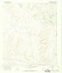
1967 Map of Owens Creek NW
USGS Topo · Published 1970About this map
The D K McMullan Jr Ranch and F McMullan Jr Ranch anchor this West Texas landscape, illustrating the family-based ranching operations that defined Crockett County in the late 1960s. The terrain is deeply marked by the transition from cattle to carbon, as the Escondido Oil Field and the expansive West World Oil Field dominate the eastern and northern reaches of the quadrangle. These industrial footprints are connected by an extensive network of pipelines and access roads that crisscross the arid plateaus.
Find a feature on this map
12 named features on this map. Tap any name to fly to it.
Don’t see what you’re looking for? This feature index may not catch every label — zoom into the map to look around manually.
Map Details
Editions of this 1967 Owens Creek NW Map
This is the sole edition of this map. No revisions or reprints were ever made.
Other maps of this area

1928 · Rankin
USGS Topo · 1:125,000

1929 · Sheffield
USGS Topo · 1:125,000

1954 · Sonora
USGS Topo · 1:250,000

1954 · San Angelo
USGS Topo · 1:250,000

1958 · Sonora
USGS Topo · 1:250,000

1958 · San Angelo
USGS Topo · 1:250,000

1965 · San Angelo
USGS Topo · 1:250,000

1967 · Owens Creek SE
USGS Topo · 1:24,000

1967 · Owens Creek NE
USGS Topo · 1:24,000

1967 · Twelvemile Camp
USGS Topo · 1:24,000