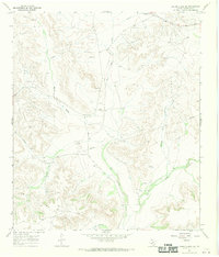
1967 Map of Owens Creek SW
USGS Topo · Published 1970About this map
Live Oak Creek carves through this West Texas landscape, defining a terrain dominated by the mid-century energy economy and livestock ranching. The 1960s footprint of the petroleum industry is evident in the sprawling Shannon Oil Field, Simpson Canyon Oil Field, and Clara Couch Oil Field, which are marked by numerous oil wells and a Pumping Sta. These industrial zones are interspersed with established family holdings such as the Hoover Ranch and Owens Ranch. The map also reveals a complex network of water and energy infrastructure, including an Aqueduct and multiple pipelines crossing the draws. Topographic features like Knute Draw, Double Tank Canyon, and J M Canyon underscore the arid, dissected character of this Crockett County region during a peak period of resource extraction.
Find a feature on this map
18 named features on this map. Tap any name to fly to it.
Don’t see what you’re looking for? This feature index may not catch every label — zoom into the map to look around manually.
Map Details
Editions of this 1967 Owens Creek SW Map
This is the sole edition of this map. No revisions or reprints were ever made.
Other maps of this area

1929 · Sheffield
USGS Topo · 1:125,000

1954 · Sonora
USGS Topo · 1:250,000

1958 · Sonora
USGS Topo · 1:250,000

1967 · Owens Creek SE
USGS Topo · 1:24,000

1967 · Owens Creek NE
USGS Topo · 1:24,000

1967 · Twelvemile Camp
USGS Topo · 1:24,000

1967 · Deer Canyon
USGS Topo · 1:24,000

1967 · Fort Lancaster
USGS Topo · 1:24,000

1967 · Bachelor Hill
USGS Topo · 1:24,000
1967 · Sheffield
USGS Topo · 1:24,000