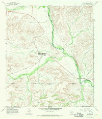
1967 Map of Sheffield
USGS Topo · Published 1970About this map
The Pecos River carves a deep valley through this arid West Texas landscape, serving as the historical boundary for Pecos and Crockett counties. The town of Sheffield is the central hub of activity, featuring the Greer Airfield and the Sheffield Cem. This era of development is defined by petroleum exploration and ranching infrastructure, evidenced by the Half Field Oil Field and numerous water-pumping stations such as the Banner Trap Windmill and Cripple Goose Windmill. Steep canyons like Hog Musk Canyon and prominent elevations including Squaw Peak and Saddle Ridge dominate the topography. Natural water sources are scarce, making Pecos Spring and the seasonal drainage of Fourmile Draw and Twomile Draw vital features of the regional geography during the late 1960s.
Find a feature on this map
27 named features on this map. Tap any name to fly to it.
Don’t see what you’re looking for? This feature index may not catch every label — zoom into the map to look around manually.
Map Details
Editions of this 1967 Sheffield Map
This is the sole edition of this map. No revisions or reprints were ever made.
Other maps of this area

1929 · Sheffield
USGS Topo · 1:125,000

1954 · Sonora
USGS Topo · 1:250,000

1958 · Sonora
USGS Topo · 1:250,000

1967 · Divide Country
USGS Topo · 1:24,000

1967 · Sheffield NW
USGS Topo · 1:24,000

1967 · Horsehead Canyon
USGS Topo · 1:24,000

1967 · Deer Canyon
USGS Topo · 1:24,000

1967 · Fort Lancaster
USGS Topo · 1:24,000

1967 · Sheffield SE
USGS Topo · 1:24,000

1967 · Dead Man Canyon
USGS Topo · 1:24,000