
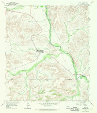
1967 Map of Horsehead Canyon
USGS Topo · Published 1970About this map
Independence Creek winds through the heart of this Terrell County landscape, serving as the primary drainage for an intricate network of deep-cut canyons. The 1960s terrain is characterized by a series of prominent landforms including Bearfoot Canyon, Surveyor Canyon, and Horsehead Canyon, reflecting the arid geography of the Trans-Pecos. This era of land use is defined by energy infrastructure and water management, evidenced by multiple Pipeline corridors crossing the draws and a Pumping Sta located near Mitchell Draw. The map also captures the extent of local resource extraction, marking specific locations for Gas Wells, an Oil Well, and a Drill Hole. These features illustrate the industrial footprint on this remote Texas ranchland before modern expansions, offering a look at the essential connection between water sources and mineral development.
Find a feature on this map
13 named features on this map. Tap any name to fly to it.
Don’t see what you’re looking for? This feature index may not catch every label — zoom into the map to look around manually.
Map Details
Editions of this 1967 Horsehead Canyon Map
This is the sole edition of this map. No revisions or reprints were ever made.
Other maps of this area

1928 · Sanderson
USGS Topo · 1:125,000

1929 · Sheffield
USGS Topo · 1:125,000

1929 · Independence Draw Quadrangle
USGS Topo · 1:125,000

1954 · Fort Stockton
USGS Topo · 1:250,000

1954 · Sonora
USGS Topo · 1:250,000

1958 · Sonora
USGS Topo · 1:250,000

1958 · Fort Stockton
USGS Topo · 1:250,000

1967 · Sheffield NW
USGS Topo · 1:24,000

1967 · Sheffield SE
USGS Topo · 1:24,000
1967 · Sheffield
USGS Topo · 1:24,000