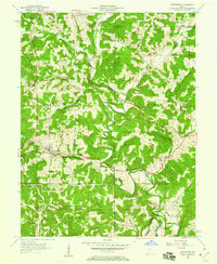
1957 Map of Owensburg
USGS Topo · Published 1958About this map
Indian Creek and its many tributaries, including Popcorn Creek and Mitchell Branch, carve a complex drainage pattern across this 1950s landscape. The settlement of Owensburg serves as a local hub, situated near Tunnel Hill along the route of Indiana 54. To the north, the small community of Hobbieville sits near the Monroe County line. The southern portion of the map is dominated by the sprawling boundaries of the U S Naval Reservation Crane Ammunition Depot, showing a significant military presence adjacent to the Hoosier National Forest.
Find a feature on this map
35 named features on this map. Tap any name to fly to it.
Don’t see what you’re looking for? This feature index may not catch every label — zoom into the map to look around manually.
Map Details
Editions of this 1957 Owensburg Map
2 editions found
Other maps of this area

1908 · Bloomington
USGS Topo · 1:48,000

1908 · Bloomfield
USGS Topo · 1:62,500

1910 · Bloomington
USGS Topo · 1:62,500

1935 · Oolitic
USGS Topo · 1:48,000

1942 · Oolitic
USGS Topo · 1:62,500

1953 · Indianapolis
USGS Topo · 1:250,000

1956 · Indianapolis
USGS Topo · 1:250,000
1956 · Clear Creek
USGS Topo · 1:24,000
1956 · Stanford
USGS Topo · 1:24,000

1956 · Koleen
USGS Topo · 1:24,000