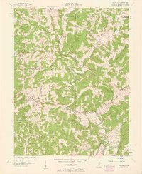
1957 Map of Owensburg
USGS Topo · Published 1959About this map
Owensburg sits at the heart of this mid-century landscape where the winding course of Indian Creek dictates the movement of roads and settlements. To the south, a significant portion of the territory is dedicated to the U S Naval Reservation Crane Ammunition Depot, marking a stark transition from the rural township sections to federal military use. This intersection of military logistics and traditional agrarian life is further defined by the inclusion of the Hoosier National Forest and localized landmarks such as Tunnel Hill.
Find a feature on this map
38 named features on this map. Tap any name to fly to it.
Don’t see what you’re looking for? This feature index may not catch every label — zoom into the map to look around manually.
Map Details
Editions of this 1957 Owensburg Map
2 editions found
Other maps of this area

1908 · Bloomington
USGS Topo · 1:48,000

1908 · Bloomfield
USGS Topo · 1:62,500

1910 · Bloomington
USGS Topo · 1:62,500

1935 · Oolitic
USGS Topo · 1:48,000

1942 · Oolitic
USGS Topo · 1:62,500

1953 · Indianapolis
USGS Topo · 1:250,000

1956 · Indianapolis
USGS Topo · 1:250,000
1956 · Clear Creek
USGS Topo · 1:24,000
1956 · Stanford
USGS Topo · 1:24,000

1956 · Koleen
USGS Topo · 1:24,000