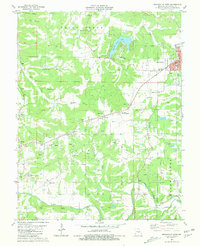
1981 Map of Owensville West
USGS Topo · Published 1981About this map
Clay mining dominates the rural landscape of Gasconade County in this early 1980s look at the region surrounding Owensville. Dozens of Claypits and Kilns are scattered throughout the hills, particularly near the St Louis-San Francisco railroad line. This industrial activity sits alongside long-established rural institutions, including numerous family and community burial grounds such as Old United Methodist Cem, Branson Cem, and Richardson Cem. The map provides a detailed view of small settlements like Canaan and Bland, as well as the more modern development at Peaceful Valley Lake. Waterways like Red Oak Creek and Clear Fork snake through the terrain, which is also marked by specialized landmarks such as a Lookout Tower and a Pumping Station near the southern border.
Find a feature on this map
44 named features on this map. Tap any name to fly to it.
Don’t see what you’re looking for? This feature index may not catch every label — zoom into the map to look around manually.
Map Details
Editions of this 1981 Owensville West Map
This is the sole edition of this map. No revisions or reprints were ever made.
Other maps of this area

1903 · Sullivan
USGS Topo · 1:125,000

1934 · Bland
USGS Topo · 1:62,500

1934 · Redbird
USGS Topo · 1:62,500

1935 · Gerald
USGS Topo · 1:48,000

1937 · Bland
USGS Topo · 1:62,500

1938 · Redbird
USGS Topo · 1:62,500

1941 · Gerald
USGS Topo · 1:62,500

1944 · Gerald
USGS Topo · 1:62,500

1948 · Oak Hill
USGS Topo · 1:24,000

1949 · Saint Louis
USGS Topo · 1:250,000