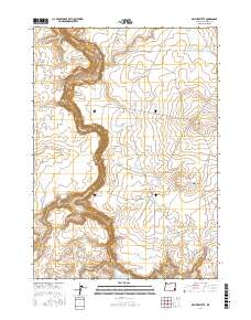
2017 Map of Owyhee Butte
USGS Topo · Published 2017About this map
Owyhee Canyon dominates this high-desert landscape in Malheur County, where the Owyhee River carves a deep, winding path through volcanic terrain. The geological history is written in the earth here, particularly evident in the expansive Saddle Butte Lava Field in the northwest and the prominent peaks of Owyhee Butte and Little Owyhee Butte. Human activity in this arid region centers on water management, as seen in the series of irrigation and stock ponds including Eiguren Reservoir Number 1, Eiguren Reservoir Number 2, and the White Rock Reservoir. These sites, along with tributaries like Crooked Cr and Granite Cr, illustrate the essential infrastructure required for ranching and survival in the Oregon backcountry. Remote transit routes, such as Tub Springs Rd and the Old Ion Hwy, skirt the canyon edges, linking this isolated terrain to the broader region.
Find a feature on this map
21 named features on this map. Tap any name to fly to it.
Don’t see what you’re looking for? This feature index may not catch every label — zoom into the map to look around manually.
Map Details
Editions of this 2017 Owyhee Butte Map
This is the sole edition of this map. No revisions or reprints were ever made.
Other maps of this area

1955 · Jordan Valley
USGS Topo · 1:250,000
1955 · Boise
USGS Topo · 1:250,000

1957 · Jordan Valley
USGS Topo · 1:250,000
1958 · Boise
USGS Topo · 1:250,000

1958 · Jordan Valley
USGS Topo · 1:250,000
1962 · Boise
USGS Topo · 1:250,000
1972 · Wrangle Butte
USGS Topo · 1:24,000
1972 · Owyhee Butte
USGS Topo · 1:24,000
1972 · Lambert Rocks
USGS Topo · 1:24,000
1972 · Rome
USGS Topo · 1:24,000