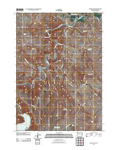
2011 Map of Owyhee Dam
USGS Topo · Published 2011About this map
Owyhee Dam and the northern reaches of Lake Owyhee dominate this high-desert landscape in eastern Oregon. The engineering of the Owyhee Project is prominently detailed, showing the intricate system of the North Canal and the Snively Siphon as they navigate the complex terrain. The Owyhee River carves through deep canyons, flanked by geological landmarks such as Balancing Rock, Pinnacle Point, and Deer Butte. Thermal activity is noted at Snively Hot Spring and a second Hot Spring further downstream. Upland areas are dotted with essential water management features for the region's arid climate, including the Chaney Reservoir, Oke Reservoir, and Mahogany Long Draw Reservoir. The road network, including Owyhee Lake Rd and the service paths like Upper Tunnel Rd, reflects the infrastructure necessary for both the dam's operation and the area's agricultural irrigation.
Find a feature on this map
31 named features on this map. Tap any name to fly to it.
Don’t see what you’re looking for? This feature index may not catch every label — zoom into the map to look around manually.
Map Details
Editions of this 2011 Owyhee Dam Map
This is the sole edition of this map. No revisions or reprints were ever made.
Other maps of this area
1906 · Mitchell Butte
USGS Topo · 1:125,000
1955 · Boise
USGS Topo · 1:250,000
1958 · Boise
USGS Topo · 1:250,000
1962 · Boise
USGS Topo · 1:250,000
1967 · Graveyard Point
USGS Topo · 1:24,000
1967 · Owyhee Dam
USGS Topo · 1:24,000
1967 · The Elbow
USGS Topo · 1:24,000
1967 · Double Mtn
USGS Topo · 1:24,000
1967 · Adrian
USGS Topo · 1:24,000
1967 · Owyhee
USGS Topo · 1:24,000