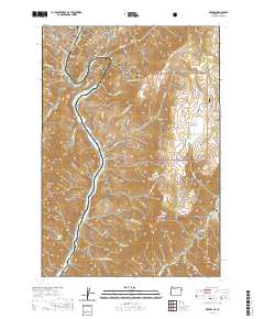
2020 Map of Oxbow
USGS Topo · Published 2020About this map
The Oxbow dominates this segment of the Snake River canyon, where the state line divides Oxbow, Oregon, from the steep slopes of the Payette National Forest in Idaho. This dramatic hairpin curve in the river defines the local geography, surrounded by high-elevation landmarks such as Sheep Peak, Little Sheep Peak, and Sheep Mtn. The terrain is deeply incised by numerous drainages, including Gore Gulch, Limestone Gulch, and Blue Jay Gulch, which feed into the main river channel and its tributaries like the Wildhorse River.
Find a feature on this map
45 named features on this map. Tap any name to fly to it.
Don’t see what you’re looking for? This feature index may not catch every label — zoom into the map to look around manually.
Map Details
Editions of this 2020 Oxbow Map
This is the sole edition of this map. No revisions or reprints were ever made.
Other maps of this area

1920 · Seven Devils Mining District
USGS Topo · 1:48,000

1955 · Baker
USGS Topo · 1:250,000

1955 · Grangeville
USGS Topo · 1:250,000

1957 · Cuprum
USGS Topo · 1:62,500

1957 · Homestead
USGS Topo · 1:62,500

1957 · Copperfield
USGS Topo · 1:62,500

1957 · Hornet
USGS Topo · 1:62,500

1959 · Baker
USGS Topo · 1:250,000

1959 · Grangeville
USGS Topo · 1:250,000

1980 · McCall
USGS Topo · 1:100,000