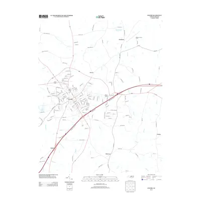
2013 Map of Oxford
USGS Topo · Published 2013About this map
Oxford serves as the focal point of this Granville County landscape, where the town's dense street grid transitions into a surrounding network of rural communities and crossroads. The map illustrates a developed corridor moving southwest toward Belltown and southeast toward Dickerson, following the path of major transit lines. To the northeast, the Henderson-Oxford Airport sits near Huntsboro, while the western edge is defined by the waters of Lake Devin. The drainage patterns of Fishing Cr, Coon Cr, and Tabbs Cr dictate the agricultural and residential layout of the area. This 2013 survey provides a clear view of local infrastructure, including industrial areas along E Industry Dr and the educational and institutional presence signified by features like the Vance-Granville Institute Pond.
Find a feature on this map
152 named features on this map. Tap any name to fly to it.
Don’t see what you’re looking for? This feature index may not catch every label — zoom into the map to look around manually.
Map Details
Editions of this 2013 Oxford Map
This is the sole edition of this map. No revisions or reprints were ever made.
Other maps of this area

1943 · Creedmoor
USGS Topo · 1:62,500

1944 · Creedmoor
USGS Topo · 1:62,500

1953 · Oxford
USGS Topo · 1:62,500

1953 · Greensboro
USGS Topo · 1:250,000

1954 · Greensboro
USGS Topo · 1:250,000

1962 · Greensboro
USGS Topo · 1:250,000

1966 · Greensboro
USGS Topo · 1:250,000

1966 · Oxford
USGS Topo · 1:62,500
1970 · Townsville
USGS Topo · 1:24,000

1970 · Henderson
USGS Topo · 1:24,000