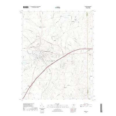
2019 Map of Oxford
USGS Topo · Published 2019About this map
Oxford serves as the focal point of this Granville County landscape, where the town's grid meets the modern thoroughfares of the Oxford Outer Loop. The map documents the community's infrastructure in the late 2010s, showing the concentration of civic spaces such as Plummer Cheatham Memorial Park and several local burial grounds, including Elmwood Cem and the Crews Family Cem further north. This modern survey reflects the area's continued role as a regional hub, with the Henderson-Oxford Airport situated to the northeast near Huntsboro.
Find a feature on this map
133 named features on this map. Tap any name to fly to it.
Don’t see what you’re looking for? This feature index may not catch every label — zoom into the map to look around manually.
Map Details
Editions of this 2019 Oxford Map
This is the sole edition of this map. No revisions or reprints were ever made.
Other maps of this area

1943 · Creedmoor
USGS Topo · 1:62,500

1944 · Creedmoor
USGS Topo · 1:62,500

1953 · Oxford
USGS Topo · 1:62,500

1953 · Greensboro
USGS Topo · 1:250,000

1954 · Greensboro
USGS Topo · 1:250,000

1962 · Greensboro
USGS Topo · 1:250,000

1966 · Greensboro
USGS Topo · 1:250,000

1966 · Oxford
USGS Topo · 1:62,500
1970 · Townsville
USGS Topo · 1:24,000

1970 · Henderson
USGS Topo · 1:24,000