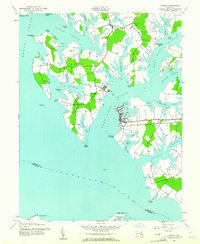
1942 Map of Oxford
USGS Topo · Published 1981About this map
Oxford occupies a prominent peninsula where the Tred Avon River meets the wide Choptank River, serving as a focal point for maritime and rail activity in the early 1940s. The Pennsylvania Railroad terminates in the heart of town near Town Creek, highlighting the importance of this port for regional commerce. Across the water, the settlement of Bellevue is linked to the mainland by a Ferry, a vital transport connection for residents of Ferry Neck and Deep Neck. The landscape is defined by intricate tidal inlets such as Irish Creek and Boone Creek, which carve into the timbered necks of land. Local life centers on established institutions like the St Paul Ch and Royal Oak Sch in the northern village of Royal Oak, while Oxford Cem and the John Wesley Ch stand as long-standing landmarks on the Oxford Neck peninsula.
Find a feature on this map
55 named features on this map. Tap any name to fly to it.
Don’t see what you’re looking for? This feature index may not catch every label — zoom into the map to look around manually.
Map Details
Editions of this 1942 Oxford Map
3 editions found
Other maps of this area

1892 · Annapolis
USGS Topo · 1:62,500

1893 · Sharps Island
USGS Topo · 1:62,500

1898 · Choptank
USGS Topo · 1:125,000

1904 · St. Michaels
USGS Topo · 1:62,500

1904 · Annapolis
USGS Topo · 1:62,500

1904 · Sharps Island
USGS Topo · 1:62,500

1904 · Oxford
USGS Topo · 1:62,500

1908 · Choptank
USGS Topo · 1:125,000

1942 · Tilghman
USGS Topo · 1:31,680

1942 · Oxford
USGS Topo · 1:31,680