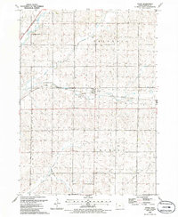
1985 Map of Oyens
USGS Topo · Published 1986About this map
Oyens serves as the central hub of this mid-1980s topographical study, situated at the junction of agricultural commerce and rail transport. The village is positioned along the Illinois Central Gulf railroad, while the northwestern corner of the quadrangle is traversed by the Chicago and North Western line. This intersection of two major rail systems reflects the region's enduring reliance on the movement of grain and goods across the Iowa plains.
Find a feature on this map
16 named features on this map. Tap any name to fly to it.
Don’t see what you’re looking for? This feature index may not catch every label — zoom into the map to look around manually.
Map Details
Editions of this 1985 Oyens Map
This is the sole edition of this map. No revisions or reprints were ever made.
Other maps of this area

1954 · Fort Dodge
USGS Topo · 1:250,000

1955 · Sioux City
USGS Topo · 1:250,000

1957 · Fort Dodge
USGS Topo · 1:250,000

1958 · Sioux City
USGS Topo · 1:250,000

1958 · Fort Dodge
USGS Topo · 1:250,000

1959 · Sioux City
USGS Topo · 1:250,000

1962 · Le Mars
USGS Topo · 1:62,500

1962 · Union Center
USGS Topo · 1:62,500
1969 · Granville West
USGS Topo · 1:24,000
1969 · Remsen
USGS Topo · 1:24,000