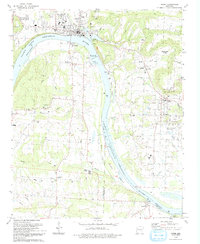
1993 Map of Ozark
USGS Topo · Published 1993About this map
Ozark sits at a pivotal bend in the Arkansas River, serving as a central hub in this early 1990s topographic study. The landscape is defined by the massive infrastructure of the Ozark-Jeta Taylor Lock and Dam, which regulates the river as it transitions from Ozark Lake into Lake Dardanelle. This waterway, punctuated by Guthrie Island and Sand Island, historically dictated the development of river-oriented settlements like Roseville and South Ozark. Away from the banks, the map reveals a dense network of local landmarks, from the Arkansas Valley Tech Institute to numerous country congregations and burial grounds such as Corinth Ch and Morgan Hill Cem. The presence of several radio towers and the growth of Wiederkehr Village reflect the region's late-century expansion beyond its traditional agricultural and mining roots.
Find a feature on this map
53 named features on this map. Tap any name to fly to it.
Don’t see what you’re looking for? This feature index may not catch every label — zoom into the map to look around manually.
Map Details
Editions of this 1993 Ozark Map
This is the sole edition of this map. No revisions or reprints were ever made.
Other maps of this area

1879 · Cravens
USGS Topo · 1:62,500

1887 · Magazine Mountain #1
USGS Topo · 1:62,500

1887 · Magazine Mountain #2
USGS Topo · 1:62,500

1887 · Watalula
USGS Topo · 1:62,500

1887 · Magazine Mountain
USGS Topo · 1:62,500

1890 · Magazine Mountain
USGS Topo · 1:125,000

1906 · Batson
USGS Topo · 1:62,500

1939 · Watalula
USGS Topo · 1:62,500

1956 · Russellville
USGS Topo · 1:250,000

1961 · Coal Hill
USGS Topo · 1:24,000