
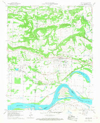
1961 Map of Coal Hill
USGS Topo · Published 1962About this map
Coal Hill and the surrounding mining district dominate this 1961 landscape in Johnson County, where the industrial footprint of extractive labor is etched into the terrain. Numerous instances of Strip Mine operations, a Mine Dump, and several Quarry sites follow the path of the Missouri Pacific railroad, which served as the primary transit artery through Alix and Denning. The map reveals a high density of small family and community burial grounds, including Houston Cem, Huddleston Cem, and Srygley Cem, providing a detailed record for genealogical research in this rural corridor.
Find a feature on this map
36 named features on this map. Tap any name to fly to it.
Don’t see what you’re looking for? This feature index may not catch every label — zoom into the map to look around manually.
Map Details
Editions of this 1961 Coal Hill Map
2 editions found
Other maps of this area

1879 · Cravens
USGS Topo · 1:62,500

1887 · Magazine Mountain #1
USGS Topo · 1:62,500

1887 · Magazine Mountain #2
USGS Topo · 1:62,500

1887 · Watalula
USGS Topo · 1:62,500

1887 · Magazine Mountain
USGS Topo · 1:62,500

1890 · Magazine Mountain
USGS Topo · 1:125,000

1906 · Batson
USGS Topo · 1:62,500

1939 · Watalula
USGS Topo · 1:62,500

1956 · Russellville
USGS Topo · 1:250,000
1961 · Hartman
USGS Topo · 1:24,000