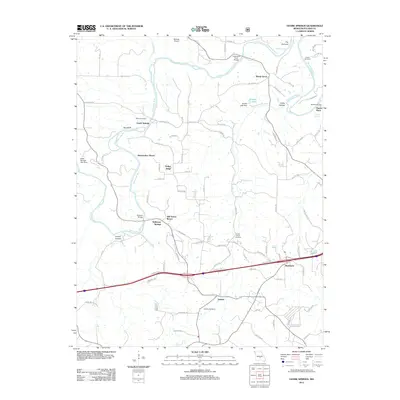
2012 Map of Ozark Springs
USGS Topo · Published 2012About this map
The Gasconade River winds through this portion of Pulaski County, defining a landscape marked by steep bluffs and narrow valley passages. Near the northern bend of the river, The Narrows and Red Bluff overlook a series of established rural settlements and private retreats. The map records a concentration of leisure sites along the water, including Kiesewetter Resort, Still House Resort, and the mineral waters of Stillhouse Springs. This recreation-focused development sits alongside long-established local landmarks like Shady Grove and Ozark Springs.
Find a feature on this map
83 named features on this map. Tap any name to fly to it.
Don’t see what you’re looking for? This feature index may not catch every label — zoom into the map to look around manually.
Map Details
Editions of this 2012 Ozark Springs Map
This is the sole edition of this map. No revisions or reprints were ever made.
Other maps of this area

1936 · Waynesville
USGS Topo · 1:48,000

1941 · Big Piney
USGS Topo · 1:62,500

1942 · Waynesville
USGS Topo · 1:62,500

1943 · Richland
USGS Topo · 1:62,500

1943 · Big Piney
USGS Topo · 1:62,500

1943 · Drynob
USGS Topo · 1:62,500

1944 · Waynesville
USGS Topo · 1:62,500

1954 · Springfield
USGS Topo · 1:250,000
1954 · Hancock
USGS Topo · 1:24,000

1954 · Drynob
USGS Topo · 1:62,500