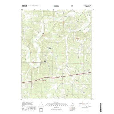
2017 Map of Ozark Springs
USGS Topo · Published 2017About this map
The Gasconade River winds through this section of Pulaski County, carving a landscape defined by deep valleys and sharp ridges such as Turkey Ridge and The Narrows. At this point in the early 21st century, the area around Waynesville and Buckhorn reflects a mixture of rural Missouri settlements and the protected woodlands of the Mark Twain National Forest. The map documentation highlights the importance of local water sources, identifying Ozark Springs, Stillhouse Springs, and Creasy Spring. Local heritage is anchored by scattered burial grounds, including Parsons Cem, Dodd's Cem, and Bartlett Cem. Transportation routes like State Hwy NN and Riddle Rd connect these outlying communities, while the Lundstrum Ford Bridge and Mokane Bridge provide critical crossings over the river and its tributaries in a region characterized by significant relief and numerous named hollows like York Hollow and Laquey Hollow.
Find a feature on this map
101 named features on this map. Tap any name to fly to it.
Don’t see what you’re looking for? This feature index may not catch every label — zoom into the map to look around manually.
Map Details
Editions of this 2017 Ozark Springs Map
This is the sole edition of this map. No revisions or reprints were ever made.
Other maps of this area

1936 · Waynesville
USGS Topo · 1:48,000

1941 · Big Piney
USGS Topo · 1:62,500

1942 · Waynesville
USGS Topo · 1:62,500

1943 · Richland
USGS Topo · 1:62,500

1943 · Big Piney
USGS Topo · 1:62,500

1943 · Drynob
USGS Topo · 1:62,500

1944 · Waynesville
USGS Topo · 1:62,500

1954 · Springfield
USGS Topo · 1:250,000
1954 · Hancock
USGS Topo · 1:24,000

1954 · Drynob
USGS Topo · 1:62,500