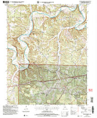
2004 Map of Ozark Springs
USGS Topo · Published 2006About this map
The Gasconade River carves a deep, winding path through this Pulaski County landscape, defining the rural character of settlements like Ozark Springs and Shady Grove. Topography compiled in the early 1950s and revised in the 2000s reveals a network of ridges and springs, including Stillhouse Springs and Creasy Spring. The southern portion of the quadrangle is dominated by the Mark Twain National Forest, where smaller settlements like Buckhorn sit along the path of Historic Route 66. Local history is preserved in several family-named landmarks and cemeteries, such as Mayse Cem near Red Bluff and Parsons Cem deep within the forest boundary. The crossing at Mokane Bridge and the narrow ridge known as The Narrows show how the local road system, including Richland Road and Republic Road, has long been constrained by the river's serpentine course.
Find a feature on this map
41 named features on this map. Tap any name to fly to it.
Don’t see what you’re looking for? This feature index may not catch every label — zoom into the map to look around manually.
Map Details
Editions of this 2004 Ozark Springs Map
This is the sole edition of this map. No revisions or reprints were ever made.
Other maps of this area

1936 · Waynesville
USGS Topo · 1:48,000

1941 · Big Piney
USGS Topo · 1:62,500

1942 · Waynesville
USGS Topo · 1:62,500

1943 · Richland
USGS Topo · 1:62,500

1943 · Big Piney
USGS Topo · 1:62,500

1943 · Drynob
USGS Topo · 1:62,500

1944 · Waynesville
USGS Topo · 1:62,500

1954 · Springfield
USGS Topo · 1:250,000
1954 · Hancock
USGS Topo · 1:24,000

1954 · Drynob
USGS Topo · 1:62,500