
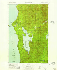
1935 Map of Ozette Lake
USGS Topo · Published 1957About this map
Ozette Lake dominates this coastal landscape, situated just inland from the Pacific shoreline where an Abandoned Indian Village sits within the Ozette Indian Reservation. The mapping, based on 1930s surveys by the Corps of Engineers, details a transition from rugged coastal points like Cape Alava to a dense network of homesteads and prairie clearings. Small-scale industry and early settlement efforts are evidenced by the Abandoned Logging Camp near the South End of the lake and the Starbuck Mine to the south. Genealogists can find numerous family-named landmarks including Pete Rooses Ranch, Ahlstroms Prairie, and the Lone Wolf Cabin. A poignant historical marker, the Swedish Memorial Jan 1903, stands near the mouth of Cedar Creek, while an Old Cemetery is noted on the western shore of Allens Bay.
Find a feature on this map
93 named features on this map. Tap any name to fly to it.
Don’t see what you’re looking for? This feature index may not catch every label — zoom into the map to look around manually.
Map Details
Editions of this 1935 Ozette Lake Map
2 editions found
Other maps of this area

1935 · Clallam
USGS Topo · 1:62,500

1935 · Lake Pleasant
USGS Topo · 1:62,500

1938 · Cape Flattery
USGS Topo · 1:62,500

1939 · Forks
USGS Topo · 1:62,500

1942 · Clallam
USGS Topo · 1:62,500

1942 · Ozette Lake
USGS Topo · 1:62,500

1942 · Lake Pleasant
USGS Topo · 1:62,500

1943 · Copalis Beach
USGS Topo · 1:250,000

1951 · Copalis Beach
USGS Topo · 1:250,000

1953 · Cape Flattery
USGS Topo · 1:250,000