
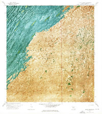
1972 Map of Pa Hay Okee Lookout Tower
USGS Topo · Published 1976About this map
Shark Valley Slough dominates this 1972 orthophotomap, showing the intricate hydrological patterns of the southern Florida wetlands just as modern conservation efforts were taking shape. The aerial perspective highlights the distinct vegetative streaks of the Everglades National Park, where elevated tree islands like Papaya Hammock provide relief from the surrounding sawgrass marsh. Human interaction with this landscape is marked by the Airboat Trail and vital water management infrastructure such as a Gaging Sta. The Pa-Hay-Okee Lookout Tower stands as a primary landmark for visitors and researchers, positioned near the transition to Rock Reef Pass. This sheet captures the transition between Monroe and Dade counties, providing a clear record of the area's natural drainage and limited transit routes through the heart of the Glades.
Find a feature on this map
11 named features on this map. Tap any name to fly to it.
Don’t see what you’re looking for? This feature index may not catch every label — zoom into the map to look around manually.
Map Details
Editions of this 1972 Pa Hay Okee Lookout Tower Map
This is the sole edition of this map. No revisions or reprints were ever made.
Other maps of this area

1956 · Miami
USGS Topo · 1:250,000

1958 · Miami
USGS Topo · 1:250,000

1972 · Whitewater Bay East
USGS Topo · 1:24,000

1972 · Mahogany Hammock
USGS Topo · 1:24,000

1972 · Taylor Slough
USGS Topo · 1:24,000

1972 · Long Pine Key
USGS Topo · 1:24,000

1972 · Panther Mound
USGS Topo · 1:24,000

1972 · Tarpon Bay
USGS Topo · 1:24,000

1972 · Indian Camp Creek
USGS Topo · 1:24,000
1972 · Black Hammock
USGS Topo · 1:24,000