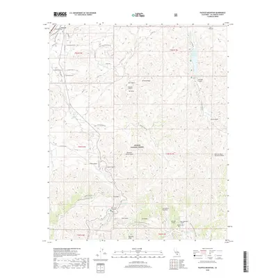
2018 Map of Pacifico Mountain
USGS Topo · Published 2018About this map
Angeles National Forest dominates this section of the San Gabriel Mountains, where the high desert of the north meets steep ridges. The Pacific Crest National Scenic Trail winds through the southern terrain, crossing near Mill Creek Summit and passing just south of Pacifico Mtn. To the northwest, the settlement of Vincent marks a key transit point near Soledad Pass, where the headwaters of the Santa Clara River begin their descent. The landscape is defined by its verticality, with named ridges like Mt Emma Ridge and deep cuts such as Soledad Canyon and Kentucky Springs Canyon. Water sources are sparse but critical in this arid environment, evidenced by Little Rock Reservoir in the northeast and several isolated springs, including Aliso Spring and Fountainhead Spring. A network of utility and service roads, such as the Pacific Telephone Access Rd and the Santiago Truck Trl, provides modern access through the complex canyon systems.
Find a feature on this map
46 named features on this map. Tap any name to fly to it.
Don’t see what you’re looking for? This feature index may not catch every label — zoom into the map to look around manually.
Map Details
Editions of this 2018 Pacifico Mountain Map
This is the sole edition of this map. No revisions or reprints were ever made.
Other maps of this area

1900 · Tujunga
USGS Topo · 1:62,500

1901 · Southern California Sheet No. 1
USGS Topo · 1:250,000

1903 · Rock Creek
USGS Topo · 1:62,500

1904 · Southern California Sheet No. 1
USGS Topo · 1:250,000

1915 · Elizabeth Lake
USGS Topo · 1:125,000

1917 · Elizabeth Lake
USGS Topo · 1:125,000

1930 · Little Rock
USGS Topo · 1:24,000

1930 · Pearland
USGS Topo · 1:24,000

1932 · Palmdale
USGS Topo · 1:24,000

1934 · Pearland
USGS Topo · 1:24,000