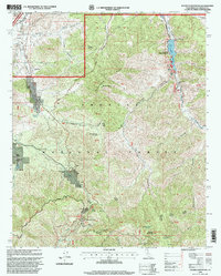
1995 Map of Pacifico Mountain
USGS Topo · Published 1999About this map
Pacifico Mountain rises as a central landmark in this high-altitude portion of the Angeles National Forest, where the landscape is defined by deep drainages like Santiago Canyon and Aliso Canyon. The map documents a rugged territory where recreational and industrial interests meet, featuring the Little Rock Resort situated along the Little Rock Reservoir and the Gold Dust Mine tucked into the mountain slopes. Transportation corridors such as the Angeles Forest Highway and Mount Emma Road provide access to remote outposts and ranches.
Find a feature on this map
60 named features on this map. Tap any name to fly to it.
Don’t see what you’re looking for? This feature index may not catch every label — zoom into the map to look around manually.
Map Details
Editions of this 1995 Pacifico Mountain Map
This is the sole edition of this map. No revisions or reprints were ever made.
Other maps of this area

1900 · Tujunga
USGS Topo · 1:62,500

1901 · Southern California Sheet No. 1
USGS Topo · 1:250,000

1903 · Rock Creek
USGS Topo · 1:62,500

1904 · Southern California Sheet No. 1
USGS Topo · 1:250,000

1915 · Elizabeth Lake
USGS Topo · 1:125,000

1917 · Elizabeth Lake
USGS Topo · 1:125,000

1930 · Little Rock
USGS Topo · 1:24,000

1930 · Pearland
USGS Topo · 1:24,000

1932 · Palmdale
USGS Topo · 1:24,000

1934 · Pearland
USGS Topo · 1:24,000