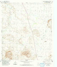
1983 Map of Packsaddle Mountain
USGS Topo · Published 1991About this map
Packsaddle Mountain dominates this Brewster County landscape, its distinctive profile rising above a network of desert drainages and isolation. The land's rugged character is defined by landmarks like Panther Mountain and the Red Bluff, while life in this arid region was historically anchored to water sources such as the Cheosa Waterhole, Terlingua Creek, and the Alamo de Cesario Cr. Evidence of human activity is sparse but significant, shown through a solitary Mine near the base of the central peak and two clear Landing Strips, indicating the remote nature of the terrain where air travel provided essential access. The presence of a Water Tank and Nine Point Draw further emphasizes the importance of managing scarce resources in the High Desert during the late twentieth century.
Find a feature on this map
11 named features on this map. Tap any name to fly to it.
Don’t see what you’re looking for? This feature index may not catch every label — zoom into the map to look around manually.
Map Details
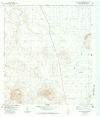
Editions of this 1983 Packsaddle Mountain Map
2 editions found
Other maps of this area

1903 · Chisos Mountains
USGS Topo · 1:125,000

1903 · Terlingua
USGS Topo · 1:125,000

1904 · Terlingua
USGS Topo · 1:125,000

1905 · Chisos Mountains
USGS Topo · 1:125,000

1917 · Agua Fria
USGS Topo · 1:62,500

1918 · Bone Spring
USGS Topo · 1:125,000

1918 · Nine Point Mesa
USGS Topo · 1:62,500

1937 · Nine Point Mesa
USGS Topo · 1:62,500

1937 · Agua Fria
USGS Topo · 1:62,500

1959 · Emory Peak
USGS Topo · 1:250,000