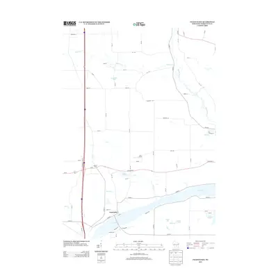
2013 Map of Packwaukee
USGS Topo · Published 2013About this map
Packwaukee sits along the northern banks of the Fox River in Marquette County, where the landscape is defined by an intricate network of waterways and glacial depressions. This 2013 survey documents the settlement patterns near the confluence of the Mad River and the Fox, showing the local road network connecting Montello Corners with surrounding farmsteads and rural properties. The abundance of named water bodies, including Christensen Lake, Pollys Lake, and Lake Emery, indicates the region's low-lying, marshy character. A notable landmark in the central part of the quadrangle is the Cacic Airport, situated between Ox Cr and the larger Montello River system. The map serves as a detailed record of contemporary Marquette County geography, from the residential streets of Packwaukee like Liberty St and Lake St to the winding course of Klawitter Cr in the north.
Find a feature on this map
45 named features on this map. Tap any name to fly to it.
Don’t see what you’re looking for? This feature index may not catch every label — zoom into the map to look around manually.
Map Details
Editions of this 2013 Packwaukee Map
This is the sole edition of this map. No revisions or reprints were ever made.
Other maps of this area

1902 · Portage
USGS Topo · 1:62,500

1902 · Briggsville
USGS Topo · 1:62,500

1957 · Madison
USGS Topo · 1:250,000

1958 · Briggsville
USGS Topo · 1:62,500

1960 · Madison
USGS Topo · 1:250,000

1961 · Oxford
USGS Topo · 1:62,500

1961 · Montello
USGS Topo · 1:62,500

1962 · Portage
USGS Topo · 1:62,500
1975 · Briggsville
USGS Topo · 1:24,000
1979 · Westfield West
USGS Topo · 1:24,000