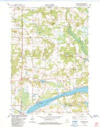
1984 Map of Packwaukee
USGS Topo · Published 1984About this map
Buffalo Lake dominates the southern landscape of this Marquette County region, where the Chicago and North Western railroad corridor tracks alongside the water toward the village of Packwaukee. The area is defined by its complex hydrology and glacial remnants, featuring numerous smaller bodies of water like Christensen Lake, Pollys Lake, and Williams Lake tucked between extensive marshes and gravel deposits. Several small private airfields, including the MCA Landing Strip and Cacic Landing Strip, reflect the mid-century aviation footprint in rural Wisconsin.
Find a feature on this map
44 named features on this map. Tap any name to fly to it.
Don’t see what you’re looking for? This feature index may not catch every label — zoom into the map to look around manually.
Map Details
Editions of this 1984 Packwaukee Map
This is the sole edition of this map. No revisions or reprints were ever made.
Other maps of this area

1902 · Portage
USGS Topo · 1:62,500

1902 · Briggsville
USGS Topo · 1:62,500

1957 · Madison
USGS Topo · 1:250,000

1958 · Briggsville
USGS Topo · 1:62,500

1960 · Madison
USGS Topo · 1:250,000

1961 · Oxford
USGS Topo · 1:62,500

1961 · Montello
USGS Topo · 1:62,500

1962 · Portage
USGS Topo · 1:62,500
1975 · Briggsville
USGS Topo · 1:24,000
1979 · Westfield West
USGS Topo · 1:24,000