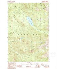
1989 Map of Packwood Lake
USGS Topo · Published 1989About this map
Packwood Lake sits at the heart of this high-altitude landscape within the Gifford Pinchot National Forest. This late-twentieth-century study documents a wilderness primarily shaped by glacial activity and steep drainage basins, featuring prominent elevations like Angry Mountain and Johnson Peak. The map highlights the primitive infrastructure of the Goat Rocks Wilderness, where access is limited to trails and points of interest such as the FS Station and a Footbridge at the northern end of the lake.
Find a feature on this map
33 named features on this map. Tap any name to fly to it.
Don’t see what you’re looking for? This feature index may not catch every label — zoom into the map to look around manually.
Map Details
Editions of this 1989 Packwood Lake Map
This is the sole edition of this map. No revisions or reprints were ever made.
Other maps of this area

1902 · Mount Aix
USGS Topo · 1:125,000

1904 · Mt Aix
USGS Topo · 1:125,000

1904 · Mount Adams
USGS Topo · 1:125,000

1907 · Mount Adams
USGS Topo · 1:125,000

1924 · Mt Rainier
USGS Topo · 1:96,000

1926 · Steamboat Mtn
USGS Topo · 1:125,000

1928 · Mt Rainier
USGS Topo · 1:125,000

1931 · Steamboat Mtn
USGS Topo · 1:125,000

1950 · Yakima
USGS Topo · 1:250,000

1958 · Yakima
USGS Topo · 1:250,000