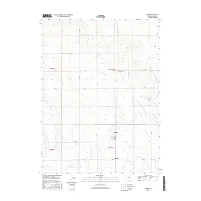
2016 Map of Padroni
USGS Topo · Published 2016About this map
The small settlement of Padroni serves as the focal point of this Logan County landscape, situated where the grid of agricultural roads meets the winding path of the North Sterling Outlet Canal. In this corner of Colorado, the land is defined by an intricate network of irrigation, including the N Sterling Lateral Number 10 and N Sterling Lateral Number 12, which draw water across the prairie. The geography transitions from the named drainage of Trap Draw in the east to the seasonal flows of Sevenmile Creek and Beall Creek.
Find a feature on this map
36 named features on this map. Tap any name to fly to it.
Don’t see what you’re looking for? This feature index may not catch every label — zoom into the map to look around manually.
Map Details
Editions of this 2016 Padroni Map
This is the sole edition of this map. No revisions or reprints were ever made.
Other maps of this area

1951 · Sterling North
USGS Topo · 1:24,000

1951 · Galien
USGS Topo · 1:24,000

1951 · Atwood NE
USGS Topo · 1:24,000

1951 · Iliff
USGS Topo · 1:24,000

1951 · Padroni NW
USGS Topo · 1:24,000

1952 · Padroni
USGS Topo · 1:24,000

1953 · Peetz
USGS Topo · 1:24,000

1954 · Sterling
USGS Topo · 1:250,000

1958 · Sterling
USGS Topo · 1:250,000
1978 · Kirchnavy Butte
USGS Topo · 1:24,000