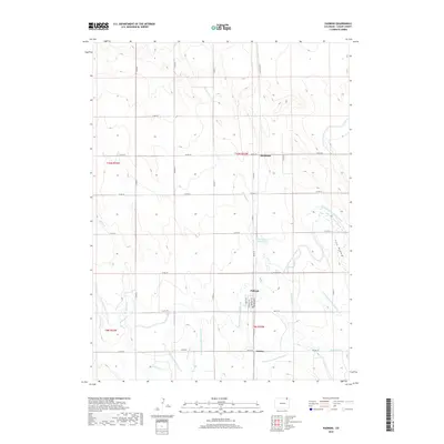
2019 Map of Padroni
USGS Topo · Published 2019About this map
Padroni serves as the central point of interest in this northeastern Colorado landscape, where the town plat reveals a street grid including Railroad Ave and Pawnee Ave. The surrounding Logan County terrain is defined by an intricate network of irrigation and water management essential to High Plains agriculture. The North Sterling Outlet Canal snakes across the eastern half of the map, supplemented by numerous numbered laterals such as N Sterling Lateral Number 8 and N Sterling Lateral Number 12. Natural drainages like Sevenmile Cr and Beall Cr cut through the plains, with the Sevenmile Water Hole providing a localized landmark. Smaller named locales like Buchanan and Jessica appear along the section lines, connected by a rectangular system of county roads that reflect the region's historical land division.
Find a feature on this map
37 named features on this map. Tap any name to fly to it.
Don’t see what you’re looking for? This feature index may not catch every label — zoom into the map to look around manually.
Map Details
Editions of this 2019 Padroni Map
This is the sole edition of this map. No revisions or reprints were ever made.
Other maps of this area

1951 · Sterling North
USGS Topo · 1:24,000

1951 · Galien
USGS Topo · 1:24,000

1951 · Atwood NE
USGS Topo · 1:24,000

1951 · Iliff
USGS Topo · 1:24,000

1951 · Padroni NW
USGS Topo · 1:24,000

1952 · Padroni
USGS Topo · 1:24,000

1953 · Peetz
USGS Topo · 1:24,000

1954 · Sterling
USGS Topo · 1:250,000

1958 · Sterling
USGS Topo · 1:250,000
1978 · Kirchnavy Butte
USGS Topo · 1:24,000