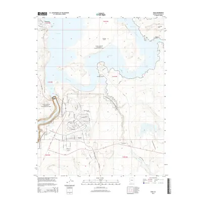
2014 Map of Page
USGS Topo · Published 2014About this map
Page serves as the central hub of this 2014 landscape, its residential and commercial street grid organized around thoroughfares like N Navajo Dr and S Navajo Dr. The town is positioned atop the plateau overlooking the Glen Canyon National Recreation Area, where the massive reservoir of Lake Powell defines the region's geography. Significant infrastructure supports the area, including the Page Municipal Airport and a complex network of access roads such as Dam Access Rd and Tunnel Access Rd.
Find a feature on this map
68 named features on this map. Tap any name to fly to it.
Don’t see what you’re looking for? This feature index may not catch every label — zoom into the map to look around manually.
Map Details
Editions of this 2014 Page Map
This is the sole edition of this map. No revisions or reprints were ever made.
Other maps of this area

1886 · Escalante
USGS Topo · 1:250,000

1886 · Echo Cliffs
USGS Topo · 1:250,000

1891 · Echo Cliffs
USGS Topo · 1:250,000

1922 · Warm Creek
USGS Topo · 1:63,360

1951 · Lees Ferry NE
USGS Topo · 1:24,000

1953 · Nipple Butte
USGS Topo · 1:62,500

1953 · Gunsight Butte
USGS Topo · 1:62,500

1954 · Lees Ferry SE
USGS Topo · 1:24,000

1954 · Leche-E Rock
USGS Topo · 1:62,500

1954 · Lees Ferry
USGS Topo · 1:62,500