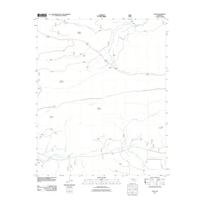
2011 Map of Page
USGS Topo · Published 2011About this map
The settlement of Page anchors this section of LeFlore County, situated along the valley of Big Creek and flanked by the rising elevations of Shawnee Ridges and Honess Mountain. The landscape is defined by its complex hydrology, where the Kiamichi River and Mountain Fork draw from numerous tributaries including Pashubbe Creek and Pigeon Creek. This 2011 survey captures the area's rural character and long-standing local landmarks, notably Page Cemetery and McClure Cemetery, which provide essential reference points for genealogists and local historians. Significant terrain features like Wilton Mountain, Quentin Peak, and Pine Mountain separate the various creek branches, illustrating how the topography influenced the development of transport routes and early settlements in this corner of the state.
Find a feature on this map
21 named features on this map. Tap any name to fly to it.
Don’t see what you’re looking for? This feature index may not catch every label — zoom into the map to look around manually.
Map Details
Editions of this 2011 Page Map
This is the sole edition of this map. No revisions or reprints were ever made.
Other maps of this area

1887 · Poteau Mountain #2
USGS Topo · 1:62,500

1890 · Poteau Mountain
USGS Topo · 1:125,000

1899 · Poteau Mountain
USGS Topo · 1:125,000

1900 · Winding Stair
USGS Topo · 1:125,000

1909 · Winding Stair
USGS Topo · 1:125,000

1950 · Mcalester
USGS Topo · 1:250,000
1958 · Loving
USGS Topo · 1:24,000
1958 · Bates
USGS Topo · 1:62,500

1958 · Potter
USGS Topo · 1:62,500

1958 · Zafra
USGS Topo · 1:24,000