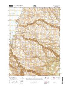
2017 Map of Page Springs
USGS Topo · Published 2017About this map
Page Springs sits at the base of the dramatic transition between the high desert plateaus and the lush wetlands of the Blitzen Valley. This high-desert landscape is defined by its sophisticated water management systems, including the Eastside Canal and West Side Canal that diversion water from the Donner und Blitzen River. Dozens of man-made structures like Knox Spring Reservoir, Butte Cr Reservoir, and the Company Trough highlight the region's historical reliance on range improvements for livestock. The map traces the famous Steens Mountain Loop as it winds through this remote Harney County terrain, providing access to the various springs and reservoirs that sustain life in this arid basin. For researchers, the density of these named water features provides a clear look at the infrastructure required to manage the high-desert range.
Find a feature on this map
32 named features on this map. Tap any name to fly to it.
Don’t see what you’re looking for? This feature index may not catch every label — zoom into the map to look around manually.
Map Details
Editions of this 2017 Page Springs Map
This is the sole edition of this map. No revisions or reprints were ever made.
Other maps of this area

1955 · Adel
USGS Topo · 1:250,000

1957 · Adel
USGS Topo · 1:250,000

1958 · Adel
USGS Topo · 1:250,000

1962 · Adel
USGS Topo · 1:250,000

1967 · Krumbo Reservoir
USGS Topo · 1:24,000

1967 · Roaring Springs
USGS Topo · 1:24,000

1967 · Frenchglen
USGS Topo · 1:24,000
1967 · Irish Lake
USGS Topo · 1:24,000

1967 · Page Springs
USGS Topo · 1:24,000

1968 · Tombstone Canyon
USGS Topo · 1:24,000