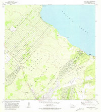
1981 Map of Pahoa North
USGS Topo · Published 1981About this map
The Nanawale Homesteads and Keonepoko Homesteads define the structured land divisions of the Puna District in the early 1980s. This survey illustrates a transitional landscape where residential subdivisions like Ainaloa Drive and Orchid Land Dr emerge from dense forest reserves and historical ahupuaʻa boundaries such as Waikahekahe Nui and Keonepoko Iki. Along the coast of the Pacific Ocean, the map identifies significant landmarks including Kaloli Point and the site of Makuu.
Find a feature on this map
37 named features on this map. Tap any name to fly to it.
Don’t see what you’re looking for? This feature index may not catch every label — zoom into the map to look around manually.
Map Details
Editions of this 1981 Pahoa North Map
2 editions found
Other maps of this area

1917 · Hilo
USGS Topo · 1:62,500

1922 · Puna
USGS Topo · 1:62,500

1924 · Makuu
USGS Topo · 1:62,500

1924 · Puna
USGS Topo · 1:62,500

1924 · Kalapana
USGS Topo · 1:62,500

1932 · Hilo
USGS Topo · 1:62,500

1954 · Hawaii South
USGS Topo · 1:250,000

1954 · Hawaii North
USGS Topo · 1:250,000

1959 · Hawaii South
USGS Topo · 1:250,000

1959 · Hawaii North
USGS Topo · 1:250,000