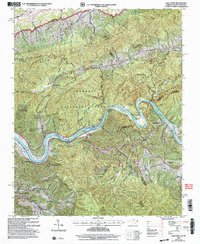
2003 Map of Paint Rock
USGS Topo · Published 2004About this map
The French Broad River carves a deep path through the Bald Mountains along the Tennessee and North Carolina border, defining the rugged geography of this 2003 revision. Small communities like Lanceville, Paint Rock, and Wolf Creek are situated along the river's winding banks, while the Southern railroad follows the water's edge, serving as a primary transit corridor through the steep terrain. This area is heavily forested, split between the Cherokee National Forest and Pisgah National Forest.
Find a feature on this map
49 named features on this map. Tap any name to fly to it.
Don’t see what you’re looking for? This feature index may not catch every label — zoom into the map to look around manually.
Map Details
Editions of this 2003 Paint Rock Map
This is the sole edition of this map. No revisions or reprints were ever made.
Other maps of this area

1883 · Morristown
USGS Topo · 1:125,000

1892 · Greeneville
USGS Topo · 1:125,000

1893 · Mt Guyot
USGS Topo · 1:125,000

1893 · Morristown
USGS Topo · 1:125,000

1894 · Asheville
USGS Topo · 1:125,000

1895 · Morristown
USGS Topo · 1:125,000

1896 · Greeneville
USGS Topo · 1:125,000

1901 · Asheville
USGS Topo · 1:125,000

1904 · Greeneville
USGS Topo · 1:125,000

1912 · Mt Guyot
USGS Topo · 1:125,000