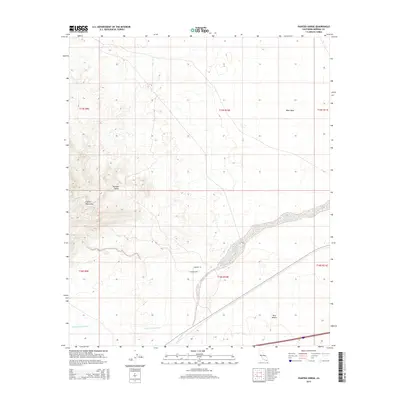
2015 Map of Painted Gorge
USGS Topo · Published 2015About this map
Coyote Mountains dominate the western portion of this Imperial County landscape, where the steep elevation contours of the range drop sharply into the arid floor of the Yuha Desert. The drainage patterns of the Colorado Desert are clearly defined by the intricate networks of Palm Canyon Wash and the S Fork Coyote Wash, which move ephemeral runoff across the basin toward Coyote Wash. To the north, the West Mesa provides a stark contrast to the deeply etched topography of the Painted Gorge, a geologic feature that draws its name from the varied mineral colors found in its walls. Human activity in this desert environment is represented by light-duty routes such as Munson Ln and Munson Trl, which navigate the transitional terrain between the mountain foothills and the expansive salt-crusted flats to the east.
Find a feature on this map
15 named features on this map. Tap any name to fly to it.
Don’t see what you’re looking for? This feature index may not catch every label — zoom into the map to look around manually.
Map Details
Editions of this 2015 Painted Gorge Map
This is the sole edition of this map. No revisions or reprints were ever made.
Other maps of this area

1915 · El Centro
USGS Topo · 1:125,000

1931 · Carrizo
USGS Topo · 1:125,000

1939 · Jacumba
USGS Topo · 1:62,500

1940 · Plaster City
USGS Topo · 1:62,500

1940 · Coyote Wells
USGS Topo · 1:62,500

1942 · El Centro
USGS Topo · 1:250,000

1942 · Carrizo Mtn
USGS Topo · 1:62,500

1942 · Jacumba
USGS Topo · 1:62,500

1943 · Coyote Wells
USGS Topo · 1:62,500

1944 · Plaster City
USGS Topo · 1:62,500