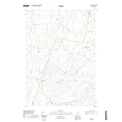
2021 Map of Palermo
USGS Topo · Published 2021About this map
Palermo and North Palermo anchor this central Maine landscape where the Kennebec Co and Waldo Co border bisects a terrain of interconnected ponds and streams. The W Br Sheepscot River flows through the heart of the area, feeding into Branch Pond and Dowe Pond near the settlement of Palermo. A high concentration of family and community burial grounds, including the Old Greeley Corner Cem and New Greeley Corner Cem, suggests a long-established rural population and provides significant data for genealogical research. The geography is defined by prominent elevations such as Level Hill and Sanford Hill, which overlook a network of water bodies like Bear Pond, Beech Pond, and Saban Pond. Numerous local routes, such as Horseback Rd and Parmenter Hill Rd, connect these scattered settlements and cemeteries, reflecting the traditional township development of the region.
Find a feature on this map
94 named features on this map. Tap any name to fly to it.
Don’t see what you’re looking for? This feature index may not catch every label — zoom into the map to look around manually.
Map Details
Editions of this 2021 Palermo Map
This is the sole edition of this map. No revisions or reprints were ever made.
Other maps of this area

1892 · Waterville
USGS Topo · 1:62,500

1893 · Vassalboro
USGS Topo · 1:62,500

1898 · Vassalboro
USGS Topo · 1:62,500

1916 · Liberty
USGS Topo · 1:62,500

1926 · Burnham
USGS Topo · 1:62,500

1941 · Vassalboro
USGS Topo · 1:62,500

1942 · Liberty
USGS Topo · 1:62,500

1943 · Vassalboro
USGS Topo · 1:62,500

1943 · Waterville
USGS Topo · 1:62,500

1948 · Bangor
USGS Topo · 1:250,000