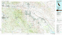
1984 Map of Palm Springs
USGS Topo · Published 1986About this map
The Coachella Valley and surrounding desert ranges appear in this mid-1980s compilation, illustrating the intensive growth of desert resort communities and the complex network of water infrastructure. The Whitewater River and the Aqueduct traverse the valley floor, supporting settlements from Palm Springs to Indio and Coachella. This era shows the expansion of Palm Desert and Cathedral City alongside long-established areas like the Agua Caliente Indian Reservation.
Find a feature on this map
115 named features on this map. Tap any name to fly to it.
Don’t see what you’re looking for? This feature index may not catch every label — zoom into the map to look around manually.
Map Details
Editions of this 1984 Palm Springs Map
3 editions found
Other maps of this area

1899 · Redlands
USGS Topo · 1:62,500

1901 · Southern California Sheet No. 1
USGS Topo · 1:250,000

1901 · San Jacinto
USGS Topo · 1:125,000

1901 · Redlands
USGS Topo · 1:62,500

1901 · Elsinore
USGS Topo · 1:125,000

1901 · San Luis Rey
USGS Topo · 1:125,000

1902 · San Gorgonio
USGS Topo · 1:125,000

1903 · Ramona
USGS Topo · 1:125,000

1904 · Indio
USGS Topo · 1:125,000

1904 · Southern California Sheet No. 2
USGS Topo · 1:250,000