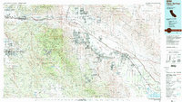
1984 Map of Palm Springs
USGS Topo · Published 1986About this map
The Coachella Valley and its surrounding desert massifs appear here in the mid-1980s, revealing the distinct patterns of resort development and agricultural expansion. Residential grids cluster around Palm Springs, Palm Desert, and Cathedral City, while the Southern Pacific railroad and Interstate 10 channel traffic through the San Gorgonio Pass. To the south and east, the desert floor transitions into a fertile landscape near Indio and Coachella, supported by the irrigation network that terminates near the Salton Sea.
Find a feature on this map
158 named features on this map. Tap any name to fly to it.
Don’t see what you’re looking for? This feature index may not catch every label — zoom into the map to look around manually.
Map Details
Editions of this 1984 Palm Springs Map
3 editions found
Other maps of this area

1899 · Redlands
USGS Topo · 1:62,500

1901 · Southern California Sheet No. 1
USGS Topo · 1:250,000

1901 · San Jacinto
USGS Topo · 1:125,000

1901 · Redlands
USGS Topo · 1:62,500

1901 · Elsinore
USGS Topo · 1:125,000

1901 · San Luis Rey
USGS Topo · 1:125,000

1902 · San Gorgonio
USGS Topo · 1:125,000

1903 · Ramona
USGS Topo · 1:125,000

1904 · Indio
USGS Topo · 1:125,000

1904 · Southern California Sheet No. 2
USGS Topo · 1:250,000