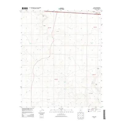
2013 Map of Palma
USGS Topo · Published 2013About this map
The high desert landscape of Torrance County is centered on the settlement of Palma, situated just south of the prominent Palma Hill. This 2013 survey illustrates the essential infrastructure of New Mexico ranching country, where water management is paramount to the local economy. The terrain is marked by a network of drainage features and artificial water sources, including Guadalupe Tank, Prairie Tank, and the notably named Rock House Tank. Remote ranching operations are anchored by landmarks such as Cecil Windmill and Carrizo Windmill, which provide vital water in an area defined by geographic features like Carrizo Canyon and Encinosa Draw. The passage of NM-3 provides the primary north-south connection through this arid region, while the northern edge of the map shows the transition toward more significant transport corridors near Encinosa Draw.
Find a feature on this map
21 named features on this map. Tap any name to fly to it.
Don’t see what you’re looking for? This feature index may not catch every label — zoom into the map to look around manually.
Map Details
Editions of this 2013 Palma Map
This is the sole edition of this map. No revisions or reprints were ever made.
Other maps of this area

1890 · Bernal
USGS Topo · 1:125,000

1891 · Bernal
USGS Topo · 1:125,000

1894 · Bernal
USGS Topo · 1:125,000

1894 · Lamy
USGS Topo · 1:125,000

1954 · Santa Fe
USGS Topo · 1:250,000

1954 · Fort Sumner
USGS Topo · 1:250,000

1958 · Fort Sumner
USGS Topo · 1:250,000

1958 · Santa Fe
USGS Topo · 1:250,000

1963 · Jacinto Mesa
USGS Topo · 1:24,000
1963 · Potrillo Hill
USGS Topo · 1:24,000