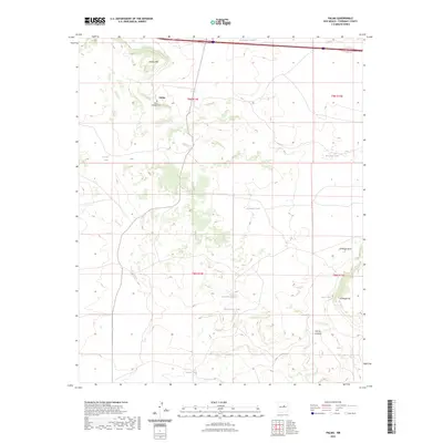
2023 Map of Palma
USGS Topo · Published 2023About this map
Palma Townsite Cem sits at the heart of this high-plateau landscape, marking the historical footprint of the Palma settlement. The terrain is defined by its water management strategy, with numerous named catchments like Guadalupe Tank, Prairie Tank, and Posodera Tank scattered across the township lines. These features indicate the long-standing ranching and livestock history of Torrance County, where reliable water sources are vital to the local economy and land use.
Find a feature on this map
19 named features on this map. Tap any name to fly to it.
Don’t see what you’re looking for? This feature index may not catch every label — zoom into the map to look around manually.
Map Details
Editions of this 2023 Palma Map
This is the sole edition of this map. No revisions or reprints were ever made.
Other maps of this area

1890 · Bernal
USGS Topo · 1:125,000

1891 · Bernal
USGS Topo · 1:125,000

1894 · Bernal
USGS Topo · 1:125,000

1894 · Lamy
USGS Topo · 1:125,000

1954 · Santa Fe
USGS Topo · 1:250,000

1954 · Fort Sumner
USGS Topo · 1:250,000

1958 · Fort Sumner
USGS Topo · 1:250,000

1958 · Santa Fe
USGS Topo · 1:250,000

1963 · Jacinto Mesa
USGS Topo · 1:24,000
1963 · Potrillo Hill
USGS Topo · 1:24,000