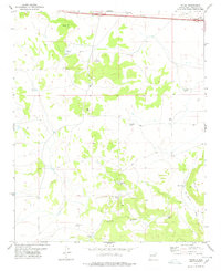
1978 Map of Palma
USGS Topo · Published 1978About this map
The small settlement of Palma serves as the focal point for this high-desert landscape in Torrance County. Established infrastructure for water management defines the region, with numerous man-made features such as Guadalupe Tank, Cecil Windmill, and Archuleta Tank dotting the terrain to support ranching operations. The topography is shaped by the prominent Palma Hill to the north and the descent into Carrizo Canyon in the south, while the El Marge Hill and its associated El Marge Draw mark the eastern reaches of the survey. A local Cem near the primary settlement provides a genealogical point of interest for those tracing family roots in this rural community. To the northeast, the Flying C Ranch sits near the interstate corridor, representing the intersection of traditional land use and modern transit. The presence of a Gravel Pit and an extensive Pipeline further indicate the modest industrial footprint within this largely open ranchland.
Find a feature on this map
24 named features on this map. Tap any name to fly to it.
Don’t see what you’re looking for? This feature index may not catch every label — zoom into the map to look around manually.
Map Details
Editions of this 1978 Palma Map
This is the sole edition of this map. No revisions or reprints were ever made.
Other maps of this area

1890 · Bernal
USGS Topo · 1:125,000

1891 · Bernal
USGS Topo · 1:125,000

1894 · Bernal
USGS Topo · 1:125,000

1894 · Lamy
USGS Topo · 1:125,000

1954 · Santa Fe
USGS Topo · 1:250,000

1954 · Fort Sumner
USGS Topo · 1:250,000

1958 · Fort Sumner
USGS Topo · 1:250,000

1958 · Santa Fe
USGS Topo · 1:250,000

1963 · Jacinto Mesa
USGS Topo · 1:24,000
1963 · Potrillo Hill
USGS Topo · 1:24,000