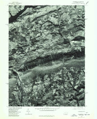
1976 Map of Palmerton
USGS Topo · Published 1978About this map
Palmerton is situated along the base of the prominent ridge line that bisects this 1976 orthophotoquad, showing the industrial and residential footprint of this Carbon County borough. The imagery captured by the U.S. Geological Survey in cooperation with the Soil Conservation Service provides a clear look at the agricultural patterns and forest cover defining the region in the mid-1970s. To the north, the waters of Beltzville Lake are visible, while the southern portion of the map covers the settlements of Slatington, Walnutport, and Danielsville. This specialized map type uses rectified aerial photography to show the exact state of land use, from the dense street grids of the boroughs to the individual farm fields and wooded slopes, offering a precise visual record of the Lehigh Valley landscape before further modern development.
Find a feature on this map
5 named features on this map. Tap any name to fly to it.
Don’t see what you’re looking for? This feature index may not catch every label — zoom into the map to look around manually.
Map Details
Editions of this 1976 Palmerton Map
This is the sole edition of this map. No revisions or reprints were ever made.
Other maps of this area

1894 · Allentown
USGS Topo · 1:62,500

1902 · Slatington
USGS Topo · 1:62,500

1914 · Wind Gap
USGS Topo · 1:62,500

1916 · Wind Gap
USGS Topo · 1:62,500

1922 · Mauch Chunk
USGS Topo · 1:62,500

1924 · Mauch Chunk
USGS Topo · 1:62,500

1937 · Allentown West
USGS Topo · 1:48,000

1939 · Allentown
USGS Topo · 1:62,500

1942 · Allentown West
USGS Topo · 1:62,500

1943 · Mauch Chunk
USGS Topo · 1:62,500