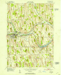
1952 Map of Palmyra
USGS Topo · Published 1953About this map
The glacial drumlin landscape of Wayne County is prominently displayed here, defined by steep north-south ridges like Johnson Hill and Cobb Hill. This 1952 topography documents the intersection of significant transport and cultural corridors, centered on the village of Palmyra. The Erie Canal and the New York Central railroad cut horizontally across the drumlin field, following the path of Ganargua Creek. To the south, the Hill Cumorah and the Angel Moroni Monument stand as landmark features of religious significance. Rural life is evidenced by a dense network of numbered schoolhouses, such as School No 1 and School No 13, and family burial grounds including Langdon Cem. The eastern portion of the map is dominated by The Wide Waters, a distinctively broad section of the canal system just north of the village of Port Gibson.
Find a feature on this map
35 named features on this map. Tap any name to fly to it.
Don’t see what you’re looking for? This feature index may not catch every label — zoom into the map to look around manually.
Map Details
Editions of this 1952 Palmyra Map
2 editions found
Other maps of this area

1899 · Palmyra
USGS Topo · 1:62,500

1900 · Macedon
USGS Topo · 1:62,500

1900 · Canandaigua
USGS Topo · 1:62,500

1902 · Phelps
USGS Topo · 1:62,500

1902 · Palmyra
USGS Topo · 1:62,500

1903 · Canandaigua
USGS Topo · 1:62,500

1942 · Ontario
USGS Topo · 1:31,680

1942 · Canandaigua
USGS Topo · 1:31,680

1943 · Phelps
USGS Topo · 1:31,680

1943 · Williamson
USGS Topo · 1:31,680