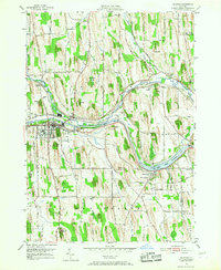
1952 Map of Palmyra
USGS Topo · Published 1968About this map
Hill Cumorah and the Angel Moroni Monument dominate the southern drumlin landscape in this mid-century survey, marking a site of significant religious heritage. The village of Palmyra serves as the central hub, situated along the historic path of the Erie Canal and the New York Central railroad. This alignment illustrates the classic transportation corridor that fueled development in western New York, with the canal widening into the distinctive basin known as The Wide Waters near Port Gibson.
Find a feature on this map
40 named features on this map. Tap any name to fly to it.
Don’t see what you’re looking for? This feature index may not catch every label — zoom into the map to look around manually.
Map Details
Editions of this 1952 Palmyra Map
2 editions found
Other maps of this area

1899 · Palmyra
USGS Topo · 1:62,500

1900 · Macedon
USGS Topo · 1:62,500

1900 · Canandaigua
USGS Topo · 1:62,500

1902 · Phelps
USGS Topo · 1:62,500

1902 · Palmyra
USGS Topo · 1:62,500

1903 · Canandaigua
USGS Topo · 1:62,500

1942 · Ontario
USGS Topo · 1:31,680

1942 · Canandaigua
USGS Topo · 1:31,680

1943 · Phelps
USGS Topo · 1:31,680

1943 · Williamson
USGS Topo · 1:31,680