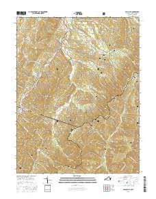
2016 Map of Palo Alto
USGS Topo · Published 2016About this map
Palo Alto sits along the State Rte 620 corridor, positioned where the high ridges of the Alleghenies meet the Virginia and West Virginia border. The landscape is dominated by the sprawling George Washington National Forest, where the terrain rises sharply toward Shenandoah Mountain and several distinctive peaks including Buffalo Knob and High Knob. This 2016 survey captures a highland environment defined by complex water systems, notably the South Fork South Branch Potomac River and its various tributaries like Crummetts Run and Brushy Fork.
Find a feature on this map
63 named features on this map. Tap any name to fly to it.
Don’t see what you’re looking for? This feature index may not catch every label — zoom into the map to look around manually.
Map Details
Editions of this 2016 Palo Alto Map
This is the sole edition of this map. No revisions or reprints were ever made.
Other maps of this area

1892 · Franklin
USGS Topo · 1:125,000

1894 · Staunton
USGS Topo · 1:125,000

1896 · Franklin
USGS Topo · 1:125,000

1922 · Fort Seybert
USGS Topo · 1:48,000

1922 · Circleville
USGS Topo · 1:62,500

1924 · Circleville
USGS Topo · 1:48,000

1924 · Mc Dowell
USGS Topo · 1:62,500

1924 · Fort Seybert
USGS Topo · 1:62,500

1944 · Parnassus
USGS Topo · 1:62,500

1944 · Mc Dowell
USGS Topo · 1:62,500