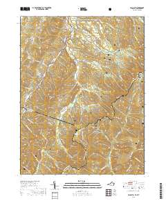
2019 Map of Palo Alto
USGS Topo · Published 2019About this map
The George Washington National Forest dominates this section of the Allegheny Mountains, where the state border divides the high ridges. The small settlement of Palo Alto sits in the valley below Buffalo Knob, marking a point of human activity near the intersection of Crummetts Run and Shaws Fork. Significant hydrologic features like Puffenbarger Pond and Warren Rexrode Spring suggest the importance of local water sources in this elevated terrain. The map tracks the headwaters of several prominent drainage systems, including the South Fork South Branch Potomac River flowing north and the Little River and N River carving through the southeastern slopes. Deep topographical features like Sinclair Hollow and Wildcat Hollow underscore the complexity of the drainage patterns flanking Shenandoah Mountain. This 2019 survey documents the modern forest road network and trails, including the Wild Oak Trail, which provides access to the high peaks and remote hollows.
Find a feature on this map
60 named features on this map. Tap any name to fly to it.
Don’t see what you’re looking for? This feature index may not catch every label — zoom into the map to look around manually.
Map Details
Editions of this 2019 Palo Alto Map
This is the sole edition of this map. No revisions or reprints were ever made.
Other maps of this area

1892 · Franklin
USGS Topo · 1:125,000

1894 · Staunton
USGS Topo · 1:125,000

1896 · Franklin
USGS Topo · 1:125,000

1922 · Fort Seybert
USGS Topo · 1:48,000

1922 · Circleville
USGS Topo · 1:62,500

1924 · Circleville
USGS Topo · 1:48,000

1924 · Mc Dowell
USGS Topo · 1:62,500

1924 · Fort Seybert
USGS Topo · 1:62,500

1944 · Parnassus
USGS Topo · 1:62,500

1944 · Mc Dowell
USGS Topo · 1:62,500